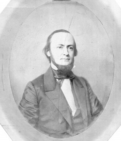
Jesse P. Haines (1783-1877) was the
cartographer/surveyor who mapped out what at the time was to become the village
of Lockport. Coming to the area in 1818,
he purchased 150 acres of land south of our present High Street and built a log
cabin for his wife Sarah Snell Haines (1788-1858) and son Thomas. Jesse and Sarah were Quakers and in 1829
donated one acre of land for a Quaker Cemetery.
That cemetery was moved a couple of times and is now located within Cold
Springs Cemetery. He made his first
official map of the village in 1830 assigning numerical designations to the
streets. Haines noted finding remains of
an ancient settlement that pre-exsisted his arrival. He found over 100 circular pits 4’ x 15’ in
diameter – then having huge trees growing from them. Thus he named the area (now Willow Street to Lincoln)
Pittsfield. Visit the History Center, 215
Niagara Street to view some of Jesse P Haines displays and to find Jesse P. Haines (1783-1877) was the cartographer/surveyor who mapped out
what at the time was to become the village of Lockport. Coming to the area in 1818, he purchased 150
acres of land south of our present High Street and built a log cabin for his
wife Sarah Snell Haines (1788-1858) and son Thomas. Jesse and Sarah were Quakers and in 1829
donated one acre of land for a Quaker Cemetery.
That cemetery was moved a couple of times and is now located within Cold
Springs Cemetery. He made his first
official map of the village in 1830 assigning numerical designations to the
streets. Haines noted finding remains of
an ancient settlement that pre-exsisted his arrival. He found over 100 circular pits 4’ x 15’ in
diameter – then having huge trees growing from them. Thus he named the area (now Willow Street to Lincoln)
Pittsfield. Visit the History Center,
215 Niagara Street to view some of Jesse P Haines displays and to find out more
historical information. out more historical information.